


breidweiler

bohynm
User
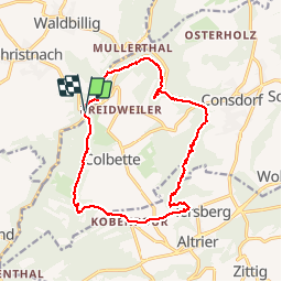

Length
14.9 km

Max alt
389 m

Uphill gradient
331 m
Km-Effort
19.3 km

Min alt
264 m

Downhill gradient
335 m
Boucle
Yes
Creation date :
2015-05-09 00:00:00.0
Updated on :
2015-05-09 00:00:00.0
4h02
Difficulty : Difficult

FREE GPS app for hiking
 SityTrail
IGN / Geographical institutes
SityTrail Plus
The world is yours!
About
Trail Walking of 14.9 km to be discovered at Unknown, Canton Echternach, Waldbillig. This trail is proposed by bohynm.
Description
nombreuses pertes de points de reperes GPS lié à la nature du terrain.... mais promenades superbe!!!!!
Photos


Positioning
Country:
Luxembourg
Region :
Unknown
Department/Province :
Canton Echternach
Municipality :
Waldbillig
Location:
Unknown
Start:(Dec)
Start:(UTM)
305055 ; 5517347 (32U) N.
Comments