


callas ripatons

vincente204
User
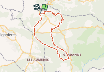

Length
17.8 km

Max alt
452 m

Uphill gradient
564 m
Km-Effort
25 km

Min alt
186 m

Downhill gradient
562 m
Boucle
Yes
Creation date :
2022-03-03 08:08:22.685
Updated on :
2022-03-03 14:16:28.104
6h07
Difficulty : Very difficult

FREE GPS app for hiking
 SityTrail
IGN / Geographical institutes
SityTrail Plus
The world is yours!
About
Trail Walking of 17.8 km to be discovered at Provence-Alpes-Côte d'Azur, Var, Callas. This trail is proposed by vincente204.
Description
difficile
Positioning
Country:
France
Region :
Provence-Alpes-Côte d'Azur
Department/Province :
Var
Municipality :
Callas
Location:
Unknown
Start:(Dec)
Start:(UTM)
301214 ; 4829154 (32T) N.
Comments