


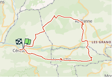
Céreste Montjustin

rlebasque
User

Length
21 km

Max alt
615 m

Uphill gradient
576 m
Km-Effort
29 km

Min alt
363 m

Downhill gradient
576 m
Boucle
Yes
Creation date :
2022-03-03 07:37:58.425
Updated on :
2022-03-03 14:21:14.87
6h42
Difficulty : Very difficult

FREE GPS app for hiking
 SityTrail
IGN / Geographical institutes
SityTrail Plus
The world is yours!
About
Trail Walking of 21 km to be discovered at Provence-Alpes-Côte d'Azur, Alpes-de-Haute-Provence, Céreste. This trail is proposed by rlebasque.
Positioning
Country:
France
Region :
Provence-Alpes-Côte d'Azur
Department/Province :
Alpes-de-Haute-Provence
Municipality :
Céreste
Location:
Unknown
Start:(Dec)
Start:(UTM)
708435 ; 4859304 (31T) N.
Comments