


Marais vernier PR

JMCMoreau
User
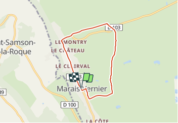

Length
5.5 km

Max alt
26 m

Uphill gradient
36 m
Km-Effort
6 km

Min alt
-1 m

Downhill gradient
35 m
Boucle
Yes
Creation date :
2022-03-05 09:41:05.02
Updated on :
2022-03-05 09:42:25.077
1h30
Difficulty : Very easy

FREE GPS app for hiking
 SityTrail
IGN / Geographical institutes
SityTrail Plus
The world is yours!
About
Trail Walking of 5.5 km to be discovered at Normandy, Eure, Marais-Vernier. This trail is proposed by JMCMoreau.
Description
Petite boucle au départ de la Mairie de Marais Vernier
Positioning
Country:
France
Region :
Normandy
Department/Province :
Eure
Municipality :
Marais-Vernier
Location:
Unknown
Start:(Dec)
Start:(UTM)
315449 ; 5477064 (31U) N.
Comments