


Playa Ingles 2022 03 05

DECHAMPD
User
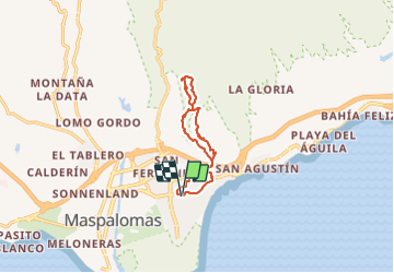

Length
13.5 km

Max alt
241 m

Uphill gradient
290 m
Km-Effort
17.4 km

Min alt
24 m

Downhill gradient
289 m
Boucle
Yes
Creation date :
2022-03-05 11:08:37.0
Updated on :
2022-03-05 18:24:13.263
5h02
Difficulty : Very easy

FREE GPS app for hiking
 SityTrail
IGN / Geographical institutes
SityTrail Plus
The world is yours!
About
Trail Walking of 13.5 km to be discovered at Canary Islands, Las Palmas, San Bartolomé de Tirajana. This trail is proposed by DECHAMPD.
Positioning
Country:
Spain
Region :
Canary Islands
Department/Province :
Las Palmas
Municipality :
San Bartolomé de Tirajana
Location:
Unknown
Start:(Dec)
Start:(UTM)
443335 ; 3070687 (28R) N.
Comments