


tour d Aqun/chapelle St Christophe

Tof Tof
User
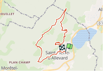

Length
9.5 km

Max alt
997 m

Uphill gradient
603 m
Km-Effort
17.5 km

Min alt
509 m

Downhill gradient
603 m
Boucle
Yes
Creation date :
2022-03-05 13:34:09.961
Updated on :
2022-03-05 16:21:34.72
2h47
Difficulty : Easy

FREE GPS app for hiking
 SityTrail
IGN / Geographical institutes
SityTrail Plus
The world is yours!
About
Trail Walking of 9.5 km to be discovered at Auvergne-Rhône-Alpes, Isère, Crêts-en-Belledonne. This trail is proposed by Tof Tof.
Positioning
Country:
France
Region :
Auvergne-Rhône-Alpes
Department/Province :
Isère
Municipality :
Crêts-en-Belledonne
Location:
Unknown
Start:(Dec)
Start:(UTM)
269009 ; 5028843 (32T) N.
Comments