


Muret

lebarça
User

Length
3.8 km

Max alt
268 m

Uphill gradient
28 m
Km-Effort
4.5 km

Min alt
161 m

Downhill gradient
125 m
Boucle
No
Creation date :
2022-03-06 14:28:25.0
Updated on :
2022-03-06 15:57:53.773
1h29
Difficulty : Very easy

FREE GPS app for hiking
 SityTrail
IGN / Geographical institutes
SityTrail Plus
The world is yours!
About
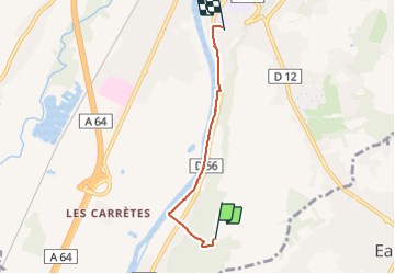
Trail Walking of 3.8 km to be discovered at Occitania, Haute-Garonne, Muret. This trail is proposed by lebarça.
Positioning
Country:
France
Region :
Occitania
Department/Province :
Haute-Garonne
Municipality :
Muret
Location:
Unknown
Start:(Dec)
Start:(UTM)
364637 ; 4809494 (31T) N.
Comments