


Struikrovers Pad long version

Geert H.
User

Length
13.8 km

Max alt
57 m

Uphill gradient
155 m
Km-Effort
15.9 km

Min alt
18 m

Downhill gradient
156 m
Boucle
Yes
Creation date :
2022-03-06 17:25:32.786
Updated on :
2022-03-07 08:17:36.272
3h36
Difficulty : Easy

FREE GPS app for hiking
 SityTrail
IGN / Geographical institutes
SityTrail Plus
The world is yours!
About
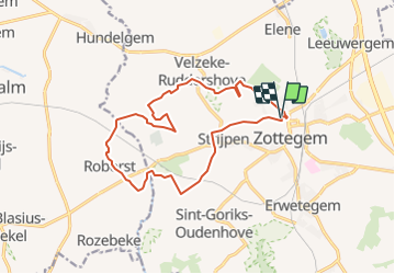
Trail Walking of 13.8 km to be discovered at Flanders, East Flanders, Zottegem. This trail is proposed by Geert H..
Description
Circular walk from Zottegem to Roborst via Strijpen and Velzeke.
Positioning
Country:
Belgium
Region :
Flanders
Department/Province :
East Flanders
Municipality :
Zottegem
Location:
Strijpen
Start:(Dec)
Start:(UTM)
556826 ; 5636026 (31U) N.
Comments