


Route from Trois-Ponts

Geert H.
User
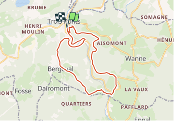

Length
15 km

Max alt
494 m

Uphill gradient
559 m
Km-Effort
22 km

Min alt
257 m

Downhill gradient
559 m
Boucle
Yes
Creation date :
2022-03-06 17:29:41.214
Updated on :
2022-03-06 17:29:41.214
5h06
Difficulty : Very difficult

FREE GPS app for hiking
 SityTrail
IGN / Geographical institutes
SityTrail Plus
The world is yours!
About
Trail Walking of 15 km to be discovered at Wallonia, Liège, Trois-Ponts. This trail is proposed by Geert H..
Positioning
Country:
Belgium
Region :
Wallonia
Department/Province :
Liège
Municipality :
Trois-Ponts
Location:
Unknown
Start:(Dec)
Start:(UTM)
704287 ; 5583671 (31U) N.
Comments