


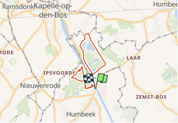
Route from Rondom Humbeek sas

Geert H.
User

Length
11.2 km

Max alt
23 m

Uphill gradient
78 m
Km-Effort
12.3 km

Min alt
3 m

Downhill gradient
78 m
Boucle
Yes
Creation date :
2022-03-06 17:29:42.03
Updated on :
2022-03-06 17:29:42.03
2h47
Difficulty : Difficult

FREE GPS app for hiking
 SityTrail
IGN / Geographical institutes
SityTrail Plus
The world is yours!
About
Trail Walking of 11.2 km to be discovered at Flanders, Flemish Brabant, Grimbergen. This trail is proposed by Geert H..
Positioning
Country:
Belgium
Region :
Flanders
Department/Province :
Flemish Brabant
Municipality :
Grimbergen
Location:
Humbeek
Start:(Dec)
Start:(UTM)
597559 ; 5648335 (31U) N.
Comments