


Rondom de Berendries

Geert H.
User
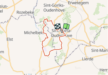

Length
10.7 km

Max alt
98 m

Uphill gradient
193 m
Km-Effort
13.2 km

Min alt
30 m

Downhill gradient
193 m
Boucle
Yes
Creation date :
2022-03-06 17:29:48.097
Updated on :
2022-03-06 17:29:48.097
3h00
Difficulty : Difficult

FREE GPS app for hiking
 SityTrail
IGN / Geographical institutes
SityTrail Plus
The world is yours!
About
Trail Walking of 10.7 km to be discovered at Flanders, East Flanders, Zottegem. This trail is proposed by Geert H..
Positioning
Country:
Belgium
Region :
Flanders
Department/Province :
East Flanders
Municipality :
Zottegem
Location:
Sint-Maria-Oudenhove
Start:(Dec)
Start:(UTM)
556031 ; 5631616 (31U) N.
Comments