


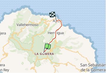
Alto de Contadero to Agulo

Geert H.
User

Length
13.3 km

Max alt
994 m

Uphill gradient
276 m
Km-Effort
19.7 km

Min alt
-1 m

Downhill gradient
1067 m
Boucle
No
Creation date :
2022-03-06 17:29:56.015
Updated on :
2022-03-06 17:29:56.015
4h27
Difficulty : Very difficult

FREE GPS app for hiking
 SityTrail
IGN / Geographical institutes
SityTrail Plus
The world is yours!
About
Trail Walking of 13.3 km to be discovered at Canary Islands, Santa Cruz de Tenerife, Hermigua. This trail is proposed by Geert H..
Positioning
Country:
Spain
Region :
Canary Islands
Department/Province :
Santa Cruz de Tenerife
Municipality :
Hermigua
Location:
Unknown
Start:(Dec)
Start:(UTM)
281338 ; 3112622 (28R) N.
Comments