


St- Bauzille-de-la-Sylve (Le Télégraphe - Le Mont Nègre)

Thierry Lucile
User
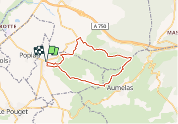

Length
13.5 km

Max alt
265 m

Uphill gradient
304 m
Km-Effort
17.5 km

Min alt
86 m

Downhill gradient
304 m
Boucle
Yes
Creation date :
2022-03-07 09:59:15.399
Updated on :
2022-03-07 10:57:09.336
3h58
Difficulty : Easy

FREE GPS app for hiking
 SityTrail
IGN / Geographical institutes
SityTrail Plus
The world is yours!
About
Trail On foot of 13.5 km to be discovered at Occitania, Hérault, Saint-Bauzille-de-la-Sylve. This trail is proposed by Thierry Lucile.
Description
Dénivelé cumulé modéré. Télégraphe Chappe bien restauré. Quelques jolis Mas.

Positioning
Country:
France
Region :
Occitania
Department/Province :
Hérault
Municipality :
Saint-Bauzille-de-la-Sylve
Location:
Unknown
Start:(Dec)
Start:(UTM)
544195 ; 4829451 (31T) N.
Comments
rando très agréable avec des points de vues dégagés.