


Chamchaude

oliviergau
User
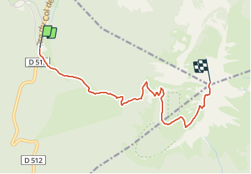

Length
3.3 km

Max alt
2034 m

Uphill gradient
701 m
Km-Effort
10.4 km

Min alt
1327 m

Downhill gradient
23 m
Boucle
No
Creation date :
2022-03-07 11:31:06.028
Updated on :
2022-03-07 14:04:00.257
2h32
Difficulty : Very easy

FREE GPS app for hiking
 SityTrail
IGN / Geographical institutes
SityTrail Plus
The world is yours!
About
Trail Touring skiing of 3.3 km to be discovered at Auvergne-Rhône-Alpes, Isère, Sarcenas. This trail is proposed by oliviergau.
Positioning
Country:
France
Region :
Auvergne-Rhône-Alpes
Department/Province :
Isère
Municipality :
Sarcenas
Location:
Unknown
Start:(Dec)
Start:(UTM)
716976 ; 5018953 (31T) N.
Comments