


Chessy-Les-Mines - Rhône (15 km - D. 360 m) CV

Thomasdanielle
User
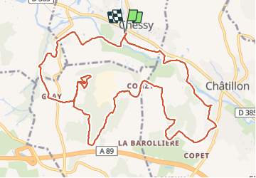

Length
14.7 km

Max alt
421 m

Uphill gradient
359 m
Km-Effort
19.5 km

Min alt
210 m

Downhill gradient
360 m
Boucle
Yes
Creation date :
2022-03-07 08:34:20.0
Updated on :
2022-03-11 18:01:07.627
4h09
Difficulty : Medium

FREE GPS app for hiking
 SityTrail
IGN / Geographical institutes
SityTrail Plus
The world is yours!
About
Trail Walking of 14.7 km to be discovered at Auvergne-Rhône-Alpes, Rhône, Chessy. This trail is proposed by Thomasdanielle.
Description
D/A : Parking à droite après le passage niveau (stade)
Photos
 CV - Photo 1")
 CV - Photo 2")
 CV - Photo 3")
Positioning
Country:
France
Region :
Auvergne-Rhône-Alpes
Department/Province :
Rhône
Municipality :
Chessy
Location:
Unknown
Start:(Dec)
Start:(UTM)
625735 ; 5082634 (31T) N.
Comments