Trail Walking Saint-Aubin-des-Châteaux - Etangs et calvaire de St Aubin des Chateaux 13km - Photo

Etangs et calvaire de St Aubin des Chateaux 13km

 yago1404
yago1404

User

© OpenStreetMap contributors
Length
Length
12.7 km
Max alt
Max alt
82 m
Uphill gradient
Uphill gradient
130 m
Km-Effort
Km-Effort  
14.5 km
Min alt
Min alt
31 m
Downhill gradient
Downhill gradient
140 m
Boucle
Boucle
Yes
Creation date :
2022-03-07 14:45:03.604
Updated on :
2022-03-07 15:13:17.209

(1 Reviews)

Walking
Walking
3h21
Difficulty : Difficult

Scan this QR Code to open this trail in the SityTrail application

FREE GPS app for hiking

Logo SityTrail SityTrail

IGN / Geographical institutes

Download SityTrail from the App Store Download SityTrail from Google Play

Logo SityTrail SityTrail World

The world is yours!

Download SityTrail from the App Store Download SityTrail from Google Play Download SityTrail on Huawei AppGallery

About

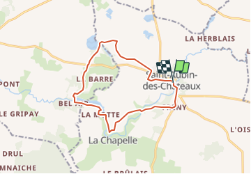
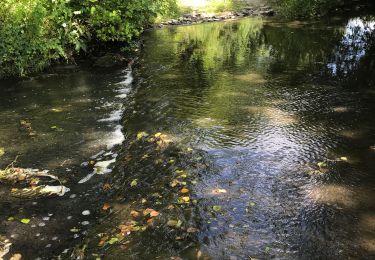
Trail Walking of 12.7 km to be discovered at Pays de la Loire, Loire-Atlantique, Saint-Aubin-des-Châteaux. This trail is proposed by yago1404.

Description

Sentier raccourci du département

Elevation profile

Positioning

Country:
France
Region :
Pays de la Loire
Department/Province :
Loire-Atlantique
Municipality :
Saint-Aubin-des-Châteaux
Location:
Unknown
Start:(UTM)
613664 ; 5286135 (30T) N.

Comments

Please log in to post a review or rate the element


impossible de passer au Moulin de Hubert. dommage


Trails nearby

Trail On foot Sion-les-Mines - Tour de l'étang de la Hunaudière - Photo
On foot
PRO

On foot

Easy
Sion-les-Mines, Pays de la Loire, Loire-Atlantique, France
5.9 km | 6.5 km-effort
1h 28min
Yes
Trail Walking Sion-les-Mines - Boucle 16 km à Saint Aubin des Chateaux - Photo
Walking
vincent35

Walking

Very easy
Sion-les-Mines, Pays de la Loire, Loire-Atlantique, France
16.3 km | 18.6 km-effort
4h 18min
Yes
Trail Walking Sion-les-Mines - La Hunaudière - Photo
Walking
tracegps

Walking

Medium
Sion-les-Mines, Pays de la Loire, Loire-Atlantique, France
11.4 km | 12.9 km-effort
2h 30min
Yes
Trail Walking Ruffigné - 15.07.2019 - RUFFIGNE à ST AUBIN DES CHÂTEAUX sud - Photo
Walking
babeth35

Walking

Difficult
Ruffigné, Pays de la Loire, Loire-Atlantique, France
28 km | 32 km-effort
7h 17min
Yes
Trail Walking Sion-les-Mines - Etang de La Hunaudière  - Photo
Walking
yago1404

Walking

Easy
Sion-les-Mines, Pays de la Loire, Loire-Atlantique, France
22 km | 24 km-effort
1h 48min
No
Trail Walking Sion-les-Mines - Sion les mines - Photo
Walking
vincent35

Walking

Very easy
Sion-les-Mines, Pays de la Loire, Loire-Atlantique, France
6.7 km | 7.3 km-effort
1h 30min
Yes
Trail Other activity Louisfert - Louisfert 8,6 km - Photo
Other activity
neoroll44

Other activity

Easy
Louisfert, Pays de la Loire, Loire-Atlantique, France
8.6 km | 9.6 km-effort
3h 0min
Yes
Trail Walking Ruffigné - St Aubin des Chateaux et Ruffigné - Photo
Walking
chasle

Walking

Easy
Ruffigné, Pays de la Loire, Loire-Atlantique, France
28 km | 32 km-effort
7h 3min
No
Trail Walking Louisfert - La Cône - Photo
Walking
neoroll44

Walking

Easy
Louisfert, Pays de la Loire, Loire-Atlantique, France
14.9 km | 16.7 km-effort
3h 42min
Yes


Close
My subscriptions