


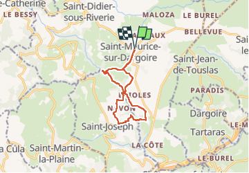
St Maurice sur Dargoire-11 a 283 g1 d35 - 0 8 03 22

jtraverse
User

Length
10.5 km

Max alt
475 m

Uphill gradient
283 m
Km-Effort
14.3 km

Min alt
287 m

Downhill gradient
282 m
Boucle
Yes
Creation date :
2022-03-07 12:42:44.184
Updated on :
2022-10-30 07:45:27.639
2h56
Difficulty : Difficult

FREE GPS app for hiking
 SityTrail
IGN / Geographical institutes
SityTrail Plus
The world is yours!
About
Trail Walking of 10.5 km to be discovered at Auvergne-Rhône-Alpes, Rhône, Chabanière. This trail is proposed by jtraverse.
Description
GPS : 45°34'58.2"N 4°37'55.1"E ou 45.582839, 4.631960
Parking de l'église , Rue de Verdun, 69440 Chabanière
Positioning
Country:
France
Region :
Auvergne-Rhône-Alpes
Department/Province :
Rhône
Municipality :
Chabanière
Location:
Saint-Maurice-sur-Dargoire
Start:(Dec)
Start:(UTM)
627312 ; 5048995 (31T) N.
Comments