


rando saint loup

lecmic
User
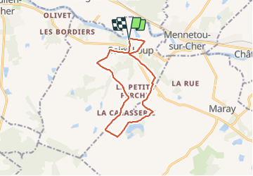

Length
12.3 km

Max alt
145 m

Uphill gradient
133 m
Km-Effort
14 km

Min alt
83 m

Downhill gradient
126 m
Boucle
Yes
Creation date :
2022-03-09 12:35:43.058
Updated on :
2022-03-09 15:59:38.446
2h55
Difficulty : Very easy

FREE GPS app for hiking
 SityTrail
IGN / Geographical institutes
SityTrail Plus
The world is yours!
About
Trail Walking of 12.3 km to be discovered at Centre-Loire Valley, Loir-et-Cher, Saint-Loup. This trail is proposed by lecmic.
Description
rando familiale
Positioning
Country:
France
Region :
Centre-Loire Valley
Department/Province :
Loir-et-Cher
Municipality :
Saint-Loup
Location:
Unknown
Start:(Dec)
Start:(UTM)
412161 ; 5235738 (31T) N.
Comments