


Nages lac et château

taguette
User
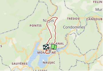

Length
11.8 km

Max alt
940 m

Uphill gradient
273 m
Km-Effort
15.4 km

Min alt
779 m

Downhill gradient
277 m
Boucle
Yes
Creation date :
2022-03-10 08:36:41.727
Updated on :
2022-03-10 11:57:17.036
2h46
Difficulty : Easy

FREE GPS app for hiking
 SityTrail
IGN / Geographical institutes
SityTrail Plus
The world is yours!
About
Trail Walking of 11.8 km to be discovered at Occitania, Tarn, Nages. This trail is proposed by taguette.
Positioning
Country:
France
Region :
Occitania
Department/Province :
Tarn
Municipality :
Nages
Location:
Unknown
Start:(Dec)
Start:(UTM)
482385 ; 4832682 (31T) N.
Comments