Trail Mountain bike Miglieglia - Pradecolo - Photo

Optez pour le retour à la nature GUIDE+
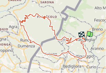
© OpenStreetMap contributors
Length
Length
27 km
Max alt
Max alt
1193 m
Uphill gradient
Uphill gradient
996 m
Km-Effort
Km-Effort  
40 km
Min alt
Min alt
467 m
Downhill gradient
Downhill gradient
990 m
Boucle
Boucle
Yes
Creation date :
2014-12-10 00:00:00.0
Updated on :
2014-12-10 00:00:00.0

(0 Reviews)

Mountain bike
Mountain bike
12h03
Difficulty : Unknown

Scan this QR Code to open this trail in the SityTrail application

FREE GPS app for hiking

Logo SityTrail SityTrail

IGN / Geographical institutes

Download SityTrail from the App Store Download SityTrail from Google Play

Logo SityTrail SityTrail Plus

The world is yours!

Download SityTrail from the App Store Download SityTrail from Google Play Download SityTrail on Huawei AppGallery

About

Trail Mountain bike of 27 km to be discovered at Ticino, Distretto di Lugano, Miglieglia. This trail is proposed by My Switzerland.

Elevation profile

Points of interest

Point of interest Miglieglia - Miglieglia - Photo
My Switzerland
MIGLIEGLIA 
Point of interest Miglieglia - Miglieglia - Photo
My Switzerland
MIGLIEGLIA 
Point of interest Dumenza - Pradecolo - Photo
My Switzerland
DUMENZA 
Point of interest Astano - Astanosee - Photo
My Switzerland
ASTANO 

Positioning

Country:
Switzerland
Region :
Ticino
Department/Province :
Distretto di Lugano
Municipality :
Miglieglia
Location:
Unknown
Start:(UTM)
488899 ; 5096672 (32T) N.


Close
My subscriptions