


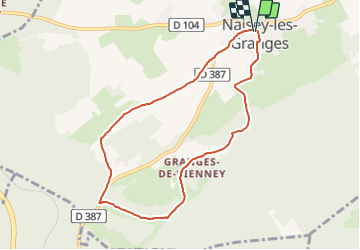
Tracé Rando NAISEY LES GRANGES

norbertmarteau
User


2h13
Difficulty : Medium

FREE GPS app for hiking
 SityTrail
IGN / Geographical institutes
SityTrail Plus
The world is yours!
About
Trail Walking of 7.7 km to be discovered at Bourgogne-Franche-Comté, Doubs, Naisey-les-Granges. This trail is proposed by norbertmarteau.
Description
Belle randonnée pédestre sans difficulté.
3 points caractéristiques :
- départ de l'église avec l'Orgue
- passage par un point de vue sur les villages environnants (de Fontain à Champlive
- Passage vers la Vierge (entrée village Hôpital du GrosBois)
Positioning
Comments