


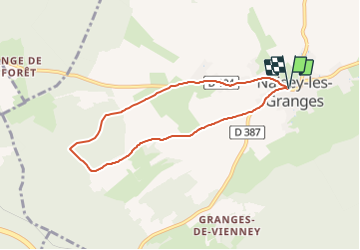
Tracé Rando 2 naisey Les Granges

norbertmarteau
User

Length
6.5 km

Max alt
492 m

Uphill gradient
81 m
Km-Effort
7.6 km

Min alt
456 m

Downhill gradient
82 m
Boucle
Yes
Creation date :
2022-03-10 13:44:40.875
Updated on :
2022-03-10 13:46:30.949
1h43
Difficulty : Medium

FREE GPS app for hiking
 SityTrail
IGN / Geographical institutes
SityTrail Plus
The world is yours!
About
Trail Walking of 6.5 km to be discovered at Bourgogne-Franche-Comté, Doubs, Naisey-les-Granges. This trail is proposed by norbertmarteau.
Description
Circuit proposé par Noël Mathey
(Eglise, 2 vierges et la chapelle à l'entrée du village (coté Saône)
Plutôt plat avec un peu de route.
Positioning
Country:
France
Region :
Bourgogne-Franche-Comté
Department/Province :
Doubs
Municipality :
Naisey-les-Granges
Location:
Unknown
Start:(Dec)
Start:(UTM)
290740 ; 5232453 (32T) N.
Comments