


Airelle
User
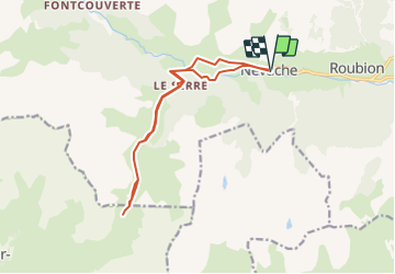

Length
14.3 km

Max alt
2428 m

Uphill gradient
864 m
Km-Effort
26 km

Min alt
1601 m

Downhill gradient
864 m
Boucle
Yes
Creation date :
2022-03-10 17:50:55.784
Updated on :
2022-03-10 17:50:55.784

FREE GPS app for hiking
 SityTrail
IGN / Geographical institutes
SityTrail Plus
The world is yours!
About
Trail of 14.3 km to be discovered at Provence-Alpes-Côte d'Azur, Hautes-Alpes, Névache. This trail is proposed by Airelle.
Positioning
Country:
France
Region :
Provence-Alpes-Côte d'Azur
Department/Province :
Hautes-Alpes
Municipality :
Névache
Location:
Unknown
Start:(Dec)
Start:(UTM)
311293 ; 4987812 (32T) N.
Comments