


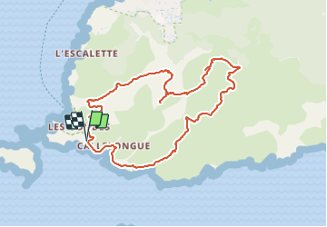
Les Goudes - Marseilleveyre - Callelongue

soca
User

Length
9.7 km

Max alt
418 m

Uphill gradient
609 m
Km-Effort
17.8 km

Min alt
7 m

Downhill gradient
610 m
Boucle
Yes
Creation date :
2022-03-11 10:45:38.963
Updated on :
2022-03-11 10:57:42.495
4h30
Difficulty : Difficult

FREE GPS app for hiking
 SityTrail
IGN / Geographical institutes
SityTrail Plus
The world is yours!
About
Trail Walking of 9.7 km to be discovered at Provence-Alpes-Côte d'Azur, Bouches-du-Rhône, Marseille. This trail is proposed by soca.
Description
Les Goudes - sommet de Marseilleveyre - col de la Serre - col de la Galinette - vallon de la Mounine- Calanque de Callelongue - les Goudes
Positioning
Country:
France
Region :
Provence-Alpes-Côte d'Azur
Department/Province :
Bouches-du-Rhône
Municipality :
Marseille
Location:
8th Arrondissement
Start:(Dec)
Start:(UTM)
690813 ; 4787197 (31T) N.
Comments