


Marcinelle-Loverval -6800m - 124m

MichelDubois
User
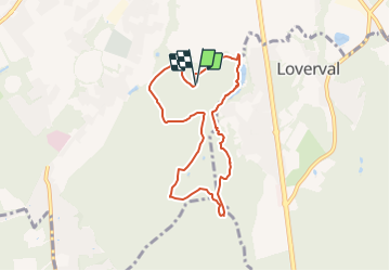

Length
6.8 km

Max alt
221 m

Uphill gradient
125 m
Km-Effort
8.5 km

Min alt
137 m

Downhill gradient
124 m
Boucle
Yes
Creation date :
2022-03-11 14:16:07.136
Updated on :
2022-03-20 06:31:22.249
1h45
Difficulty : Easy

FREE GPS app for hiking
 SityTrail
IGN / Geographical institutes
SityTrail Plus
The world is yours!
About
Trail Nordic walking of 6.8 km to be discovered at Wallonia, Hainaut, Charleroi. This trail is proposed by MichelDubois.
Positioning
Country:
Belgium
Region :
Wallonia
Department/Province :
Hainaut
Municipality :
Charleroi
Location:
Unknown
Start:(Dec)
Start:(UTM)
603509 ; 5581155 (31U) N.
Comments