


La Chapelle Vinobre

pb07
User
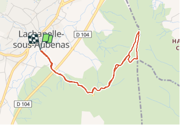

Length
4.8 km

Max alt
359 m

Uphill gradient
159 m
Km-Effort
7 km

Min alt
201 m

Downhill gradient
159 m
Boucle
Yes
Creation date :
2022-03-11 13:08:36.535
Updated on :
2022-03-11 15:08:57.114
1h59
Difficulty : Easy

FREE GPS app for hiking
 SityTrail
IGN / Geographical institutes
SityTrail Plus
The world is yours!
About
Trail Walking of 4.8 km to be discovered at Auvergne-Rhône-Alpes, Ardèche, Lachapelle-sous-Aubenas. This trail is proposed by pb07.
Positioning
Country:
France
Region :
Auvergne-Rhône-Alpes
Department/Province :
Ardèche
Municipality :
Lachapelle-sous-Aubenas
Location:
Unknown
Start:(Dec)
Start:(UTM)
608335 ; 4935318 (31T) N.
Comments