Trail Mountain bike Appenzell - Fälensee - Photo

Optez pour le retour à la nature GUIDE+
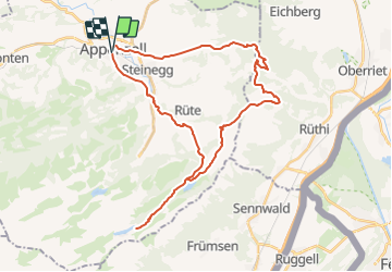
© OpenStreetMap contributors
Length
Length
37 km
Max alt
Max alt
1488 m
Uphill gradient
Uphill gradient
1255 m
Km-Effort
Km-Effort  
54 km
Min alt
Min alt
775 m
Downhill gradient
Downhill gradient
1253 m
Boucle
Boucle
Yes
Creation date :
2014-12-10 00:00:00.0
Updated on :
2014-12-10 00:00:00.0

(0 Reviews)

Mountain bike
Mountain bike
14h21
Difficulty : Unknown

Scan this QR Code to open this trail in the SityTrail application

FREE GPS app for hiking

Logo SityTrail SityTrail

IGN / Geographical institutes

Download SityTrail from the App Store Download SityTrail from Google Play

Logo SityTrail SityTrail Plus

The world is yours!

Download SityTrail from the App Store Download SityTrail from Google Play Download SityTrail on Huawei AppGallery

About

Trail Mountain bike of 37 km to be discovered at Appenzell Innerrhoden, Unknown, Appenzell. This trail is proposed by My Switzerland.

Elevation profile

Points of interest

Point of interest Oberriet -  - Photo
My Switzerland
OBERRIET 
Point of interest Rüte -  - Photo
My Switzerland
RÜTE 
Point of interest Rüte -  - Photo
My Switzerland
RÜTE 
Point of interest Rüte -  - Photo
My Switzerland
RÜTE 
Point of interest Rüte -  - Photo
My Switzerland
RÜTE 
Point of interest Schwende -  - Photo
My Switzerland
SCHWENDE 
Point of interest Appenzell - Bahnhof Appenzell - Photo
My Switzerland
Point of interest Appenzell - Bahnhof Appenzell - Photo
My Switzerland

Positioning

Country:
Switzerland
Region :
Appenzell Innerrhoden
Department/Province :
Unknown
Municipality :
Appenzell
Location:
Unknown
Start:(UTM)
530931 ; 5241760 (32T) N.


Close
My subscriptions