


clue d aiglun

baygonvert
User
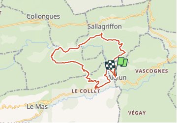

Length
17.5 km

Max alt
1162 m

Uphill gradient
1233 m
Km-Effort
34 km

Min alt
499 m

Downhill gradient
1241 m
Boucle
Yes
Creation date :
2022-03-13 08:43:00.723
Updated on :
2022-03-13 13:24:50.881
2h46
Difficulty : Medium

FREE GPS app for hiking
 SityTrail
IGN / Geographical institutes
SityTrail Plus
The world is yours!
About
Trail Trail of 17.5 km to be discovered at Provence-Alpes-Côte d'Azur, Maritime Alps, Aiglun. This trail is proposed by baygonvert.
Positioning
Country:
France
Region :
Provence-Alpes-Côte d'Azur
Department/Province :
Maritime Alps
Municipality :
Aiglun
Location:
Unknown
Start:(Dec)
Start:(UTM)
332326 ; 4858411 (32T) N.
Comments