
Epretot

DDLEDANDY
User
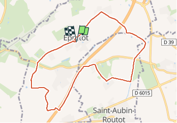

Length
9.6 km

Max alt
120 m

Uphill gradient
82 m
Km-Effort
10.7 km

Min alt
83 m

Downhill gradient
83 m
Boucle
Yes
Creation date :
2022-03-15 07:43:07.324
Updated on :
2022-03-15 09:53:47.82
2h10
Difficulty : Easy

FREE GPS app for hiking
 SityTrail
IGN / Geographical institutes
SityTrail Plus
The world is yours!
About
Trail Walking of 9.6 km to be discovered at Normandy, Seine-Maritime, Épretot. This trail is proposed by DDLEDANDY.
Photos

Positioning
Country:
France
Region :
Normandy
Department/Province :
Seine-Maritime
Municipality :
Épretot
Location:
Unknown
Start:(Dec)
Start:(UTM)
305644 ; 5490878 (31U) N.
Comments