


w_CHpur05_grandec

My Switzerland
Optez pour le retour à la nature GUIDE+
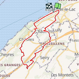

Length
15.6 km

Max alt
656 m

Uphill gradient
327 m
Km-Effort
20 km

Min alt
426 m

Downhill gradient
326 m
Boucle
Yes
Creation date :
2014-12-10 00:00:00.0
Updated on :
2014-12-10 00:00:00.0
--
Difficulty : Unknown

FREE GPS app for hiking
 SityTrail
IGN / Geographical institutes
SityTrail Plus
The world is yours!
About
Trail Walking of 15.6 km to be discovered at Fribourg, District de la Broye, Estavayer. This trail is proposed by My Switzerland.
Positioning
Country:
Switzerland
Region :
Fribourg
Department/Province :
District de la Broye
Municipality :
Estavayer
Location:
Estavayer-le-Lac
Start:(Dec)
Start:(UTM)
335340 ; 5190433 (32T) N.
Comments
