


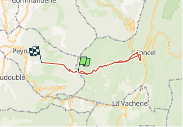
pont de Peyrus a Leoncel

verozerr
User

Length
11.3 km

Max alt
1125 m

Uphill gradient
375 m
Km-Effort
18.2 km

Min alt
460 m

Downhill gradient
960 m
Boucle
No
Creation date :
2022-03-15 13:13:33.073
Updated on :
2022-03-15 17:53:15.349
4h02
Difficulty : Medium

FREE GPS app for hiking
 SityTrail
IGN / Geographical institutes
SityTrail Plus
The world is yours!
About
Trail Nordic walking of 11.3 km to be discovered at Auvergne-Rhône-Alpes, Drôme, Peyrus. This trail is proposed by verozerr.
Description
peyrus Leoncel le 15 03 22
Positioning
Country:
France
Region :
Auvergne-Rhône-Alpes
Department/Province :
Drôme
Municipality :
Peyrus
Location:
Unknown
Start:(Dec)
Start:(UTM)
669584 ; 4974249 (31T) N.
Comments