ASFBD 2022 Parcours 6 km

psesjs
User
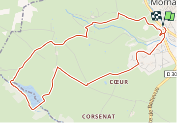

Length
6.4 km

Max alt
424 m

Uphill gradient
119 m
Km-Effort
8 km

Min alt
333 m

Downhill gradient
119 m
Boucle
Yes
Creation date :
2022-03-15 22:48:20.328
Updated on :
2022-03-19 11:06:06.444
1h48
Difficulty : Easy

FREE GPS app for hiking
 SityTrail
IGN / Geographical institutes
SityTrail Plus
The world is yours!
About
Trail Walking of 6.4 km to be discovered at Auvergne-Rhône-Alpes, Rhône, Mornant. This trail is proposed by psesjs.
Positioning
Country:
France
Region :
Auvergne-Rhône-Alpes
Department/Province :
Rhône
Municipality :
Mornant
Location:
Unknown
Start:(Dec)
Start:(UTM)
630185 ; 5052768 (31T) N.
Comments