Trail Walking Heiligenstein - De Heiligenstein au Mont Sainte Odile - Photo

De Heiligenstein au Mont Sainte Odile

 tracegps
tracegps

User

© OpenStreetMap contributors
Length
Length
13.3 km
Max alt
Max alt
816 m
Uphill gradient
Uphill gradient
640 m
Km-Effort
Km-Effort  
22 km
Min alt
Min alt
300 m
Downhill gradient
Downhill gradient
640 m
Boucle
Boucle
Yes
Creation date :
2014-12-10 00:00:00.0
Updated on :
2014-12-10 00:00:00.0

(1 Reviews)

Walking
Walking
3h30
Difficulty : Medium

Scan this QR Code to open this trail in the SityTrail application

FREE GPS app for hiking

Logo SityTrail SityTrail

IGN / Geographical institutes

Download SityTrail from the App Store Download SityTrail from Google Play

Logo SityTrail SityTrail World

The world is yours!

Download SityTrail from the App Store Download SityTrail from Google Play Download SityTrail on Huawei AppGallery

About

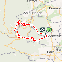
Trail Walking of 13.3 km to be discovered at Grand Est, Bas-Rhin, Heiligenstein. This trail is proposed by tracegps.

Description

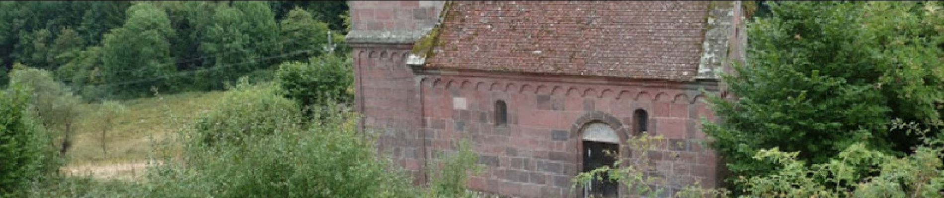
Départ de Heiligenstein, parking champêtre au bout de la rue des Châteaux. Suivre triangle bleu, d’abord à travers vignes du Klevener de Heiligenstein et vergers, puis à travers la forêt, jusqu’au château de Landsberg. Continuer sur rectangle rouge, traverser la D109, kiosque Jadelot, Wachstein, stèle de l’accident d’avion de 1992. Longer le mur païen sur chevalet jaune, dolmen, grotte des druides, porte d’entrée dans l’enceinte du mur païen. Suite sur croix bleue, tombes mérovingiennes, fontaine Saint Jean chapelle des roches et visite du couvent du Mont Sainte Odile. Possibilité de manger à la salle des pèlerins (cafétéria). A la sortie du couvent descendre à gauche sur triangle jaune, fontaine miraculeuse de Sainte Odile (maladie des yeux), abbaye de Niedermunster, chapelle Saint Nicolas. Revenir sur ses pas (500m) et continuer sur disque jaune, fontaine Zimmermann, chapelle Saint Jacques, abbaye de Truttenhausen et retour au parking.

Elevation profile

Photos

Positioning

Country:
France
Region :
Grand Est
Department/Province :
Bas-Rhin
Municipality :
Heiligenstein
Location:
Unknown
Start:(UTM)
384798 ; 5364669 (32U) N.

Comments

Please log in to post a review or rate the element


Trails nearby

Trail Walking Ottrott - Le circuit sud du Mur Païen - Photo
Walking
VacheKiri67

Walking

Easy
(2)
Ottrott, Grand Est, Bas-Rhin, France
4.9 km | 6.3 km-effort
1h 56min
No
Trail Walking Ottrott - Le circuit nord du Mur Païen - Photo
Walking
VacheKiri67

Walking

Easy
(1)
Ottrott, Grand Est, Bas-Rhin, France
5.9 km | 8.5 km-effort
2h 4min
No
Trail Walking Ottrott - Le Mont Sainte-Odile depuis Otrott - Photo
Walking
VacheKiri67

Walking

Medium
(1)
Ottrott, Grand Est, Bas-Rhin, France
13 km | 20 km-effort
6h 18min
Yes
Trail Walking Ottrott - Montée vers le Mont Sainte-Odile - Photo
Walking
VacheKiri67

Walking

Difficult
(1)
Ottrott, Grand Est, Bas-Rhin, France
17.6 km | 26 km-effort
5h 52min
Yes
Trail Walking Andlau - Depuis Andlau vers le village viticole de Mittelbergheim - Photo
Walking
VacheKiri67

Walking

Medium
(1)
Andlau, Grand Est, Bas-Rhin, France
11.9 km | 15.9 km-effort
4h 3min
Yes
Trail Walking Ottrott - Le mur païen - Photo
Walking
VacheKiri67

Walking

Medium
(4)
Ottrott, Grand Est, Bas-Rhin, France
10.5 km | 14.5 km-effort
4h 36min
Yes
Trail Walking Ottrott - Mur Paien complet - Photo
Walking
markrei

Walking

Medium
(1)
Ottrott, Grand Est, Bas-Rhin, France
12 km | 16.4 km-effort
5h 25min
Yes
Trail Walking Obernai - Obernai gare - Mont St Odile - Photo
Walking
tracegps

Walking

Difficult
(2)
Obernai, Grand Est, Bas-Rhin, France
20 km | 29 km-effort
5h 0min
Yes
Trail Mountain bike Barr - Circuit des 3 Petits Ponts - Photo
Mountain bike
tracegps

Mountain bike

Difficult
(1)
Barr, Grand Est, Bas-Rhin, France
15.9 km | 22 km-effort
1h 19min
Yes


Close
My subscriptions