Trail Walking Saint-Maur-des-Fossés - Boucle St Maur - Vincennes - Photo
 chessyca
chessyca

User

© OpenStreetMap contributors
Length
Length
22 km
Max alt
Max alt
73 m
Uphill gradient
Uphill gradient
173 m
Km-Effort
Km-Effort  
24 km
Min alt
Min alt
28 m
Downhill gradient
Downhill gradient
174 m
Boucle
Boucle
Yes
Creation date :
2022-03-16 08:31:27.949
Updated on :
2022-03-16 17:18:16.805

(0 Reviews)

Walking
Walking
5h32
Difficulty : Unknown

Scan this QR Code to open this trail in the SityTrail application

FREE GPS app for hiking

Logo SityTrail SityTrail

IGN / Geographical institutes

Download SityTrail from the App Store Download SityTrail from Google Play

Logo SityTrail SityTrail World

The world is yours!

Download SityTrail from the App Store Download SityTrail from Google Play Download SityTrail on Huawei AppGallery

About

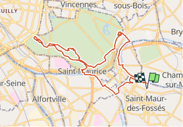
Trail Walking of 22 km to be discovered at Ile-de-France, Val-de-Marne, Saint-Maur-des-Fossés. This trail is proposed by chessyca.

Description

Sortie effectuée avec Marianne pour le RCY

Elevation profile

Photos

Positioning

Country:
France
Region :
Ile-de-France
Department/Province :
Val-de-Marne
Municipality :
Saint-Maur-des-Fossés
Location:
Unknown
Start:(UTM)
462277 ; 5406415 (31U) N.

Trails nearby

Trail Walking Neuilly-Plaisance - Neuilly Plaisance gare Rer sortie Bords de Marne/ Base Nautique Vaires sur Marne - Photo
Walking
thierry cachot

Walking

Easy
(1)
Neuilly-Plaisance, Ile-de-France, Seine-Saint-Denis, France
15.9 km | 17.1 km-effort
2h 52min
Yes
Trail Walking Noiseau - depuis Noiseau - Photo
Walking
Bernardroland

Walking

Easy
(2)
Noiseau, Ile-de-France, Val-de-Marne, France
17 km | 19.1 km-effort
4h 35min
Yes
Trail On foot Créteil - JC 84 - La Végétale - 18,2 km - Photo
On foot

On foot

Difficult
(1)
Créteil, Ile-de-France, Val-de-Marne, France
18.3 km | 21 km-effort
4h 40min
No
Trail Walking Créteil - Parc départemental et tour lac Créteil 15 km - Photo
Walking
GUIDE
jeanmarcMasson

Walking

Difficult
(1)
Créteil, Ile-de-France, Val-de-Marne, France
14.4 km | 16.2 km-effort
3h 41min
Yes
Trail On foot Sucy-en-Brie - L 08 Sucy en Brie, parc du Morbras - Photo
On foot

On foot

Very easy
(4)
Sucy-en-Brie, Ile-de-France, Val-de-Marne, France
5.7 km | 6.8 km-effort
1h 46min
Yes
Trail On foot Sucy-en-Brie - 8228189-track-1571238544-580 - Photo
On foot
gemau77

On foot

Easy
(1)
Sucy-en-Brie, Ile-de-France, Val-de-Marne, France
10.1 km | 11.3 km-effort
2h 34min
No
Trail Other activity Sucy-en-Brie - Marche - Photo
Other activity
nejman1905

Other activity

Very easy
(1)
Sucy-en-Brie, Ile-de-France, Val-de-Marne, France
15 km | 16 km-effort
3h 15min
No
Trail Walking Nogent-sur-Marne - Autour des Minimes - Photo
Walking
RbK

Walking

Very easy
(2)
Nogent-sur-Marne, Ile-de-France, Val-de-Marne, France
3.7 km | 4.1 km-effort
53min
Yes
Trail Mountain bike Fontenay-sous-Bois - vtt bois de vincennes - Photo
Mountain bike
jknc988

Mountain bike

Medium
(1)
Fontenay-sous-Bois, Ile-de-France, Val-de-Marne, France
38 km | 42 km-effort
1h 59min
Yes


Close
My subscriptions