


Tremblay balade a Louis

chasle
User
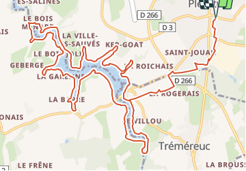

Length
19.7 km

Max alt
82 m

Uphill gradient
202 m
Km-Effort
22 km

Min alt
14 m

Downhill gradient
202 m
Boucle
Yes
Creation date :
2022-03-16 16:58:32.146
Updated on :
2022-03-16 17:10:36.926

FREE GPS app for hiking
 SityTrail
IGN / Geographical institutes
SityTrail Plus
The world is yours!
About
Trail of 19.7 km to be discovered at Brittany, Ille-et-Vilaine, Pleurtuit. This trail is proposed by chasle.
Positioning
Country:
France
Region :
Brittany
Department/Province :
Ille-et-Vilaine
Municipality :
Pleurtuit
Location:
Unknown
Start:(Dec)
Start:(UTM)
569539 ; 5381102 (30U) N.
Comments