Trail Walking Samer - Le chemin de Cappe - Samer  - Photo

Le chemin de Cappe - Samer

 tracegps
tracegps

User

© OpenStreetMap contributors
Length
Length
10.7 km
Max alt
Max alt
121 m
Uphill gradient
Uphill gradient
185 m
Km-Effort
Km-Effort  
13.2 km
Min alt
Min alt
28 m
Downhill gradient
Downhill gradient
185 m
Boucle
Boucle
Yes
Creation date :
2014-12-10 00:00:00.0
Updated on :
2014-12-10 00:00:00.0

(1 Reviews)

Walking
Walking
3h00
Difficulty : Medium

Scan this QR Code to open this trail in the SityTrail application

FREE GPS app for hiking

Logo SityTrail SityTrail

IGN / Geographical institutes

Download SityTrail from the App Store Download SityTrail from Google Play

Logo SityTrail SityTrail World

The world is yours!

Download SityTrail from the App Store Download SityTrail from Google Play Download SityTrail on Huawei AppGallery

About

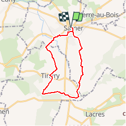
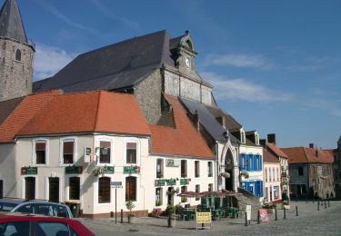
Trail Walking of 10.7 km to be discovered at Hauts-de-France, Pas-de-Calais, Samer. This trail is proposed by tracegps.

Description

Le Chemin de Cappe au départ de Samer vous propose une balade agréable et d'un niveau facile, qui vous conduira jusqu'au village de Tingry. Vous pourrez y découvrir l'Eglise Saint-Pierre du XIXème et de superbes manoirs dont la ferme du Château rouge, le Château gris et le manoir de la Haye d'Incourt du XVIème et XVIIème siècle. Durant cette balade vous pourrez y apercevoir biches, lapins etc...

Elevation profile

Photos

Positioning

Country:
France
Region :
Hauts-de-France
Department/Province :
Pas-de-Calais
Municipality :
Samer
Location:
Unknown
Start:(UTM)
411276 ; 5610462 (31U) N.

Comments

Please log in to post a review or rate the element


Trails nearby

Trail Walking Samer - Le Mont Corbeau - Samer - Photo
Walking
tracegps

Walking

Difficult
Samer, Hauts-de-France, Pas-de-Calais, France
10.1 km | 12.6 km-effort
3h 0min
Yes
Trail Mountain bike Samer - Le Haut Pichot - Samer - Photo
Mountain bike
tracegps

Mountain bike

Difficult
Samer, Hauts-de-France, Pas-de-Calais, France
32 km | 39 km-effort
3h 0min
Yes
Trail Walking Samer - Le Haut Pichot - Samer - Photo
Walking
tracegps

Walking

Difficult
Samer, Hauts-de-France, Pas-de-Calais, France
32 km | 39 km-effort
7h 0min
Yes
Trail Mountain bike Samer - Le chemin de Cappe - Samer  - Photo
Mountain bike
tracegps

Mountain bike

Medium
Samer, Hauts-de-France, Pas-de-Calais, France
10.7 km | 13.2 km-effort
1h 30min
Yes
Trail Mountain bike Samer - La Quevalerie la Vienne - Samer - Photo
Mountain bike
tracegps

Mountain bike

Medium
Samer, Hauts-de-France, Pas-de-Calais, France
5.7 km | 7.1 km-effort
1h 0min
Yes
Trail Walking Samer - La Quevalerie la Vienne - Samer - Photo
Walking
tracegps

Walking

Medium
Samer, Hauts-de-France, Pas-de-Calais, France
5.7 km | 7.1 km-effort
2h 0min
Yes
Trail Walking Samer - Le Bas Blaisel - Samer - Photo
Walking
tracegps

Walking

Medium
Samer, Hauts-de-France, Pas-de-Calais, France
7 km | 8.2 km-effort
1h 30min
Yes
Trail Walking Samer - La Blanche Jument - Samer - Photo
Walking
tracegps

Walking

Very difficult
Samer, Hauts-de-France, Pas-de-Calais, France
16.4 km | 20 km-effort
4h 10min
Yes
Trail Walking Samer - Samer le Hourquet - Photo
Walking
tenace

Walking

Difficult
Samer, Hauts-de-France, Pas-de-Calais, France
15.2 km | 17.9 km-effort
3h 45min
Yes


Close
My subscriptions