Trail Walking Luzech - De Luzech à Castelfranc - Photo

De Luzech à Castelfranc

 tracegps
tracegps

User

© OpenStreetMap contributors
Length
Length
24 km
Max alt
Max alt
278 m
Uphill gradient
Uphill gradient
582 m
Km-Effort
Km-Effort  
32 km
Min alt
Min alt
92 m
Downhill gradient
Downhill gradient
581 m
Boucle
Boucle
Yes
Creation date :
2014-12-10 00:00:00.0
Updated on :
2014-12-10 00:00:00.0

(0 Reviews)

Walking
Walking
5h00
Difficulty : Very difficult

Scan this QR Code to open this trail in the SityTrail application

FREE GPS app for hiking

Logo SityTrail SityTrail

IGN / Geographical institutes

Download SityTrail from the App Store Download SityTrail from Google Play

Logo SityTrail SityTrail World

The world is yours!

Download SityTrail from the App Store Download SityTrail from Google Play Download SityTrail on Huawei AppGallery

About

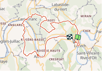
Trail Walking of 24 km to be discovered at Occitania, Lot, Luzech. This trail is proposed by tracegps.

Description

Départ de la salle des sports (salle de la Grave). Au cœur du méandre le plus resserré de la rivière Lot, la cité médiévale de Luzech, à l'ombre protectrice de sa tour a un charme indéniable: la rivière lui donne sa douceur et les collines son caractère. Rejoignez Luzech par les rives du Lot et la traversée du pont de la Douve. Passez devant l'office de tourisme, tout en suivant le GR 36 dirigez vous vers le pied de la tour de l'Impernal. Par les coteaux vous allez rejoindre les villages de Castelfranc, Albas et retour vers Luzech par les rives du Lot.

Elevation profile

Photos

Positioning

Country:
France
Region :
Occitania
Department/Province :
Lot
Municipality :
Luzech
Location:
Unknown
Start:(UTM)
363224 ; 4926610 (31T) N.

Trails nearby

Trail Walking Saint-Vincent-Rive-d'Olt - St Vincent-rive  d’Holt (Lot) - Photo
Walking
houbart

Walking

Difficult
(1)
Saint-Vincent-Rive-d'Olt, Occitania, Lot, France
11.6 km | 17.4 km-effort
3h 57min
Yes
Trail Walking Crayssac - Crayssac Cévennes  - Photo
Walking
GUIDE
antignacs

Walking

Very easy
Crayssac, Occitania, Lot, France
6.3 km | 9.1 km-effort
1h 43min
No
Trail Walking Saint-Vincent-Rive-d'Olt - Point de vue sur le cingle de Luzech - Photo
Walking
tracegps

Walking

Difficult
(1)
Saint-Vincent-Rive-d'Olt, Occitania, Lot, France
4.6 km | 7.3 km-effort
1h 30min
Yes
Trail Walking Luzech - Fages_Pech-vert_Foulquet 6,5 - Photo
Walking
PariseJL

Walking

Very easy
Luzech, Occitania, Lot, France
6.5 km | 8.9 km-effort
2h 7min
Yes
Trail Walking Castelfranc - Castelfranc Tindout 2019 02 08 - Photo
Walking
PariseJL

Walking

Easy
Castelfranc, Occitania, Lot, France
3.3 km | 4.6 km-effort
1h 42min
Yes
Trail Walking Castelfranc - Castelfranc Tindout photos  - Photo
Walking
PariseJL

Walking

Easy
Castelfranc, Occitania, Lot, France
5 km | 6.9 km-effort
2h 1min
Yes
Trail Nordic walking Caillac - la cévenne de Crayssac - Photo
Nordic walking
rouky

Nordic walking

Medium
Caillac, Occitania, Lot, France
16.1 km | 22 km-effort
2h 41min
Yes
Trail Walking Luzech - Luzech a - Photo
Walking
saligne

Walking

Medium
Luzech, Occitania, Lot, France
14 km | 20 km-effort
3h 29min
Yes
Trail Walking Luzech - Luzech 2 - Photo
Walking
saligne

Walking

Difficult
Luzech, Occitania, Lot, France
13.6 km | 19.7 km-effort
3h 33min
Yes


Close
My subscriptions