


chalencon

HAL26
User
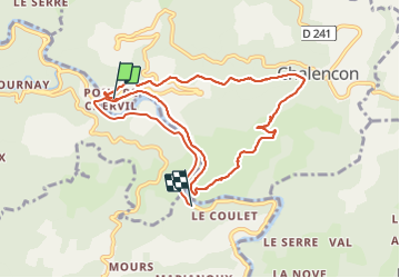

Length
11 km

Max alt
656 m

Uphill gradient
445 m
Km-Effort
16.9 km

Min alt
284 m

Downhill gradient
458 m
Boucle
No
Creation date :
2022-03-17 09:13:20.796
Updated on :
2022-03-17 13:57:20.791
4h43
Difficulty : Difficult

FREE GPS app for hiking
 SityTrail
IGN / Geographical institutes
SityTrail Plus
The world is yours!
About
Trail Walking of 11 km to be discovered at Auvergne-Rhône-Alpes, Ardèche, Chalencon. This trail is proposed by HAL26.
Positioning
Country:
France
Region :
Auvergne-Rhône-Alpes
Department/Province :
Ardèche
Municipality :
Chalencon
Location:
Unknown
Start:(Dec)
Start:(UTM)
621745 ; 4970170 (31T) N.
Comments