


luze pont nour

signorato
User
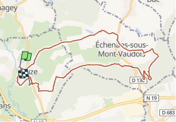

Length
12.7 km

Max alt
507 m

Uphill gradient
286 m
Km-Effort
16.4 km

Min alt
332 m

Downhill gradient
272 m
Boucle
No
Creation date :
2022-03-17 12:45:33.717
Updated on :
2022-03-17 16:33:28.412
3h47
Difficulty : Medium

FREE GPS app for hiking
 SityTrail
IGN / Geographical institutes
SityTrail Plus
The world is yours!
About
Trail Walking of 12.7 km to be discovered at Bourgogne-Franche-Comté, Haute-Saône, Luze. This trail is proposed by signorato.
Description
luze m'ont vaudois echenans
Positioning
Country:
France
Region :
Bourgogne-Franche-Comté
Department/Province :
Haute-Saône
Municipality :
Luze
Location:
Unknown
Start:(Dec)
Start:(UTM)
329948 ; 5274110 (32T) N.
Comments