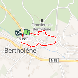
Trail Walking Bertholène - Tour du village de Bertholène - Photo

Tour du village de Bertholène

 tracegps
tracegps

User

© OpenStreetMap contributors
Length
Length
1 km
Max alt
Max alt
622 m
Uphill gradient
Uphill gradient
37 m
Km-Effort
Km-Effort  
1.5 km
Min alt
Min alt
581 m
Downhill gradient
Downhill gradient
35 m
Boucle
Boucle
Yes
Creation date :
2014-12-10 00:00:00.0
Updated on :
2014-12-10 00:00:00.0

(0 Reviews)

Walking
Walking
30m
Difficulty : Easy

Scan this QR Code to open this trail in the SityTrail application

FREE GPS app for hiking

Logo SityTrail SityTrail

IGN / Geographical institutes

Download SityTrail from the App Store Download SityTrail from Google Play

Logo SityTrail SityTrail World

The world is yours!

Download SityTrail from the App Store Download SityTrail from Google Play Download SityTrail on Huawei AppGallery

About

Trail Walking of 1 km to be discovered at Occitania, Aveyron, Bertholène. This trail is proposed by tracegps.

Description

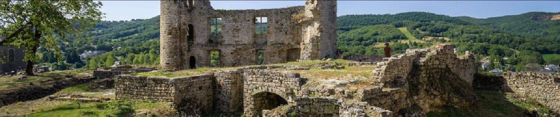
Les premières traces de la présence de l'homme à Bertholène remontent au Paléolithique. A chaque époque, des vestiges attestent de sa présence: hache polie, sépulture, de très nombreux dolmens, villa gallo-romaine. Au XIIIe siècle, les textes signalent un seigneur puis un château. Ce dernier a été remanié à toutes les périodes pour être enfin abandonné au XIXe siècle. A ce jour, il a été en partie restauré et de nombreux indices ainsi que du mobilier issus de fouilles archéologiques ont pu être découverts. Dans la deuxième moitié du XXe siècle, on extrayait du charbon, de la barytine et de l'uranium qui étaient convoyés par train sur une ligne spéciale. Aujourd'hui ces trois mines sont fermées, mais la voie ferrée subsiste encore et elle est accessible à pied ou en VTT. Retrouvez le plan et le descriptif du circuit sur le site de l'Office de Tourisme.

Elevation profile

Photos

Positioning

Country:
France
Region :
Occitania
Department/Province :
Aveyron
Municipality :
Bertholène
Location:
Unknown
Start:(UTM)
482218 ; 4915794 (31T) N.

Trails nearby

Trail Walking Bertholène - les bourines - Photo
Walking
Lacaze

Walking

Easy
Bertholène, Occitania, Aveyron, France
9 km | 11 km-effort
2h 33min
Yes
Trail Walking Bertholène - les bourines - Photo
Walking
Lacaze

Walking

Easy
(1)
Bertholène, Occitania, Aveyron, France
9 km | 11 km-effort
2h 33min
Yes
Trail Walking Bozouls - Horizons et Clochers du Rouergue - Gillorgues - Photo
Walking
tracegps

Walking

Medium
Bozouls, Occitania, Aveyron, France
11.9 km | 15.5 km-effort
3h 0min
Yes
Trail Walking Laissac-Sévérac l'Église - Tour du village de Laissac  - Photo
Walking
tracegps

Walking

Easy
Laissac-Sévérac l'Église, Occitania, Aveyron, France
1.6 km | 1.9 km-effort
30min
Yes
Trail Moto cross Montrozier - av cl 2024 - Photo
Moto cross
frank12

Moto cross

Very easy
Montrozier, Occitania, Aveyron, France
30 km | 42 km-effort
1h 0min
No
Trail Mountain bike Bertholène - bertholene bozouls Saint Côme  - Photo
Mountain bike
limo12

Mountain bike

Easy
Bertholène, Occitania, Aveyron, France
29 km | 35 km-effort
2h 23min
No
Trail Mountain bike Bertholène - ancienne voie ferrée - Photo
Mountain bike
bbertrand974

Mountain bike

Very easy
Bertholène, Occitania, Aveyron, France
22 km | 26 km-effort
1h 42min
No
Trail Walking Bozouls - Gillorgues - Photo
Walking
Lacaze

Walking

Medium
Bozouls, Occitania, Aveyron, France
10.9 km | 14.1 km-effort
3h 11min
Yes
Trail Mountain bike Laissac-Sévérac l'Église - roc laissagais 40 - Photo
Mountain bike
kayakiste15

Mountain bike

Difficult
(1)
Laissac-Sévérac l'Église, Occitania, Aveyron, France
42 km | 60 km-effort
2h 26min
Yes


Close
My subscriptions