


G4 REBOUC HECHES 2022

LouisROGER
User GUIDE
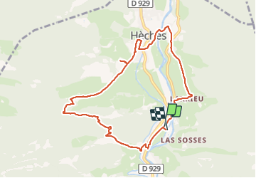

Length
9.8 km

Max alt
743 m

Uphill gradient
276 m
Km-Effort
13.5 km

Min alt
575 m

Downhill gradient
279 m
Boucle
Yes
Creation date :
2022-03-18 08:44:10.526
Updated on :
2022-03-18 13:14:43.371
3h01
Difficulty : Difficult

FREE GPS app for hiking
 SityTrail
IGN / Geographical institutes
SityTrail Plus
The world is yours!
About
Trail Walking of 9.8 km to be discovered at Occitania, Hautespyrenees, Hèches. This trail is proposed by LouisROGER.
Positioning
Country:
France
Region :
Occitania
Department/Province :
Hautespyrenees
Municipality :
Hèches
Location:
Unknown
Start:(Dec)
Start:(UTM)
286245 ; 4764304 (31T) N.
Comments