


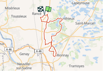
J2 - Boucle St Jean de Thurigneux (Option par Dombes)

aeldin
User

Length
28 km

Max alt
310 m

Uphill gradient
230 m
Km-Effort
31 km

Min alt
274 m

Downhill gradient
230 m
Boucle
Yes
Creation date :
2022-03-18 16:23:29.668
Updated on :
2022-04-03 17:58:13.308
0m
Difficulty : Very easy

FREE GPS app for hiking
 SityTrail
IGN / Geographical institutes
SityTrail Plus
The world is yours!
About
Trail Equestrian of 28 km to be discovered at Auvergne-Rhône-Alpes, Ain, Saint-Jean-de-Thurigneux. This trail is proposed by aeldin.

Positioning
Country:
France
Region :
Auvergne-Rhône-Alpes
Department/Province :
Ain
Municipality :
Saint-Jean-de-Thurigneux
Location:
Unknown
Start:(Dec)
Start:(UTM)
646350 ; 5091508 (31T) N.
Comments