


perpezat

Yolande Olivier
User

Length
8.9 km

Max alt
1113 m

Uphill gradient
261 m
Km-Effort
12.5 km

Min alt
977 m

Downhill gradient
282 m
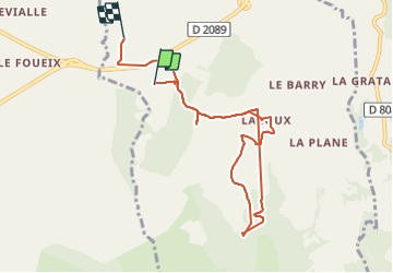
Boucle
No
Creation date :
2022-03-18 14:01:30.693
Updated on :
2022-03-18 16:43:13.211
2h26
Difficulty : Difficult

FREE GPS app for hiking
 SityTrail
IGN / Geographical institutes
SityTrail Plus
The world is yours!
About
Trail Walking of 8.9 km to be discovered at Auvergne-Rhône-Alpes, Puy-de-Dôme, Perpezat. This trail is proposed by Yolande Olivier.
Photos

Positioning
Country:
France
Region :
Auvergne-Rhône-Alpes
Department/Province :
Puy-de-Dôme
Municipality :
Perpezat
Location:
Unknown
Start:(Dec)
Start:(UTM)
482116 ; 5056132 (31T) N.
Comments