


VTT - Ezy

JMHRX2
User
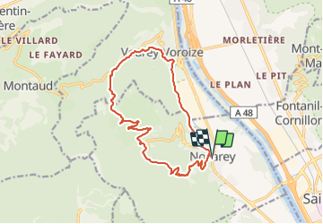

Length
15.6 km

Max alt
859 m

Uphill gradient
822 m
Km-Effort
27 km

Min alt
194 m

Downhill gradient
821 m
Boucle
Yes
Creation date :
2022-03-18 10:17:01.783
Updated on :
2022-03-18 17:15:00.179
2h35
Difficulty : Medium

FREE GPS app for hiking
 SityTrail
IGN / Geographical institutes
SityTrail Plus
The world is yours!
About
Trail Mountain bike of 15.6 km to be discovered at Auvergne-Rhône-Alpes, Isère, Noyarey. This trail is proposed by JMHRX2.
Positioning
Country:
France
Region :
Auvergne-Rhône-Alpes
Department/Province :
Isère
Municipality :
Noyarey
Location:
Unknown
Start:(Dec)
Start:(UTM)
706564 ; 5013335 (31T) N.
Comments