Trail Mountain bike Villiers-sur-Suize - 079 Circuit du Mausolée  - Photo

079 Circuit du Mausolée

© OpenStreetMap contributors
Length
Length
13.4 km
Max alt
Max alt
442 m
Uphill gradient
Uphill gradient
268 m
Km-Effort
Km-Effort  
17 km
Min alt
Min alt
327 m
Downhill gradient
Downhill gradient
266 m
Boucle
Boucle
Yes
Creation date :
2022-03-19 07:18:26.742
Updated on :
2022-03-24 17:26:19.073

(0 Reviews)

Mountain bike
Mountain bike
1h40
Difficulty : Easy

Scan this QR Code to open this trail in the SityTrail application

FREE GPS app for hiking

Logo SityTrail SityTrail

IGN / Geographical institutes

Download SityTrail from the App Store Download SityTrail from Google Play

Logo SityTrail SityTrail World

The world is yours!

Download SityTrail from the App Store Download SityTrail from Google Play Download SityTrail on Huawei AppGallery

About

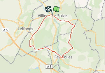
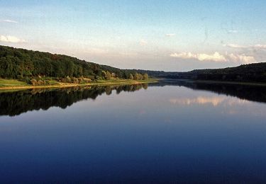
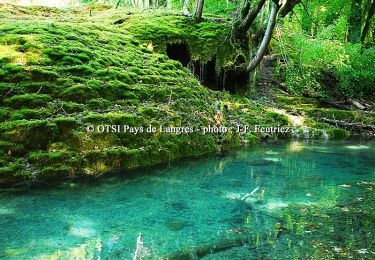
Trail Mountain bike of 13.4 km to be discovered at Grand Est, Haute-Marne, Villiers-sur-Suize. This trail is proposed by delestrai.

Description

voir fiche d'information www.tourisme-hautemarne.com fiche n°79

Elevation profile

Photos

Positioning

Country:
France
Region :
Grand Est
Department/Province :
Haute-Marne
Municipality :
Villiers-sur-Suize
Location:
Unknown
Start:(UTM)
663990 ; 5316513 (31T) N.

Trails nearby

Trail Walking Vesaignes-sur-Marne - Vesaignes Sinceron - Photo
Walking
grandjonc

Walking

Difficult
(1)
Vesaignes-sur-Marne, Grand Est, Haute-Marne, France
12.9 km | 15.9 km-effort
3h 36min
Yes
Trail Mountain bike Vesaignes-sur-Marne - Entre Vesaignes-sur-Marne et Nogent - Photo
Mountain bike
indianalou

Mountain bike

Medium
(1)
Vesaignes-sur-Marne, Grand Est, Haute-Marne, France
17.7 km | 22 km-effort
2h 0min
Yes
Trail Mountain bike Rolampont - Source de la Tuffiere - Photo
Mountain bike
delestrai

Mountain bike

Very easy
Rolampont, Grand Est, Haute-Marne, France
21 km | 25 km-effort
3h 15min
Yes
Trail Mountain bike Rolampont - SityTrail - Autour de la Tuffière - Photo
Mountain bike
delestrai

Mountain bike

Medium
Rolampont, Grand Est, Haute-Marne, France
20 km | 25 km-effort
1h 38min
Yes
Trail Mountain bike Faverolles - La Via Francigena - Traversée de la Haute Marne -de Faverolles à Langres - Photo
Mountain bike
tracegps

Mountain bike

Medium
Faverolles, Grand Est, Haute-Marne, France
24 km | 29 km-effort
2h 15min
No
Trail Walking Faverolles - La Via Francigena - Traversée de la Haute Marne -de Faverolles à Langres - Photo
Walking
tracegps

Walking

Medium
Faverolles, Grand Est, Haute-Marne, France
24 km | 29 km-effort
5h 0min
No
Trail Mountain bike Faverolles - La Fontaine du Saut - Faverolles - Photo
Mountain bike
tracegps

Mountain bike

Easy
Faverolles, Grand Est, Haute-Marne, France
10.3 km | 12.4 km-effort
1h 0min
Yes
Trail Walking Faverolles - La Fontaine du Saut - Faverolles - Photo
Walking
tracegps

Walking

Easy
Faverolles, Grand Est, Haute-Marne, France
10.3 km | 12.4 km-effort
2h 0min
Yes
Trail Mountain bike Rolampont - La Tufière de Rolampont - Faverolles - Photo
Mountain bike
tracegps

Mountain bike

Medium
Rolampont, Grand Est, Haute-Marne, France
11.5 km | 14.8 km-effort
1h 30min
Yes


Close
My subscriptions