


Cirkwi-PR_le_chemin_des_écoliers

tyntyn
User

Length
7.9 km

Max alt
909 m

Uphill gradient
283 m
Km-Effort
11.7 km

Min alt
658 m

Downhill gradient
286 m
Boucle
Yes
Creation date :
2022-03-19 11:53:09.968
Updated on :
2022-03-19 11:53:09.968

FREE GPS app for hiking
 SityTrail
IGN / Geographical institutes
SityTrail Plus
The world is yours!
About
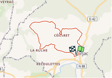
Trail of 7.9 km to be discovered at Occitania, Lozère, Barjac. This trail is proposed by tyntyn.
Description
Circuit vallonné entre Barjac et Cenaret Fléchage jaune Apres le panorama à la vierge blanche le circuit après la route devient un chemin étroit fort pentu et pas entretenu (ronces) .
Positioning
Country:
France
Region :
Occitania
Department/Province :
Lozère
Municipality :
Barjac
Location:
Unknown
Start:(Dec)
Start:(UTM)
532486 ; 4927804 (31T) N.
Comments