Ste Savines. Pierre Arnoux

Tof Tof
User
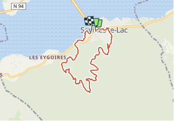

Length
8.2 km

Max alt
1300 m

Uphill gradient
549 m
Km-Effort
15.4 km

Min alt
780 m

Downhill gradient
538 m
Boucle
Yes
Creation date :
2022-03-19 12:59:38.328
Updated on :
2022-03-19 16:03:09.57
2h58
Difficulty : Easy

FREE GPS app for hiking
 SityTrail
IGN / Geographical institutes
SityTrail Plus
The world is yours!
About
Trail Walking of 8.2 km to be discovered at Provence-Alpes-Côte d'Azur, Hautes-Alpes, Savines-le-Lac. This trail is proposed by Tof Tof.
Positioning
Country:
France
Region :
Provence-Alpes-Côte d'Azur
Department/Province :
Hautes-Alpes
Municipality :
Savines-le-Lac
Location:
Unknown
Start:(Dec)
Start:(UTM)
293407 ; 4933451 (32T) N.
Comments