Trail Snowshoes Campan - Pla des Bouhouèrès - Payolle - Photo

Pla des Bouhouèrès - Payolle

 tracegps
tracegps

User

© OpenStreetMap contributors
Length
Length
13.6 km
Max alt
Max alt
1906 m
Uphill gradient
Uphill gradient
797 m
Km-Effort
Km-Effort  
24 km
Min alt
Min alt
1137 m
Downhill gradient
Downhill gradient
797 m
Boucle
Boucle
Yes
Creation date :
2014-12-10 00:00:00.0
Updated on :
2014-12-10 00:00:00.0

(0 Reviews)

Snowshoes
Snowshoes
6h30
Difficulty : Difficult

Scan this QR Code to open this trail in the SityTrail application

FREE GPS app for hiking

Logo SityTrail SityTrail

IGN / Geographical institutes

Download SityTrail from the App Store Download SityTrail from Google Play

Logo SityTrail SityTrail World

The world is yours!

Download SityTrail from the App Store Download SityTrail from Google Play Download SityTrail on Huawei AppGallery

About

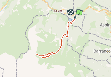
Trail Snowshoes of 13.6 km to be discovered at Occitania, Hautespyrenees, Campan. This trail is proposed by tracegps.

Description

Départ depuis le parking du bord du lac de la station touristique de Payolle. On longe tout d'abord la piste de fond qui emprunte la D113 qui conduit à la Hourquette d'Ancizan. On quitte cette piste à hauteur des cabanes de Camoudiet pour attaquer la rude montée vers le sommet. La dernière rampe pour aboutir au sommet est particulièrement raide, mais au sommet à 1916 m on découvre un immense panorama sur les sommets enneigés. La descente s'effectue par l'autre versant de la ligne de crête pour rejoindre les cabanes de Camoudiet et la piste qui reconduit au parking.

Elevation profile

Photos

Positioning

Country:
France
Region :
Occitania
Department/Province :
Hautespyrenees
Municipality :
Campan
Location:
Unknown
Start:(UTM)
279803 ; 4757230 (31T) N.

Trails nearby

Trail Walking Esparros - Du Signal de Bassia vers le col de Beyrède par la crête sud-est et le Pas de Bassia - Photo
Walking
2034

Walking

Medium
(9)
Esparros, Occitania, Hautespyrenees, France
3.2 km | 5.1 km-effort
48min
No
Trail Walking Ancizan - Lac d'Arou - Payolle - Photo
Walking
tracegps

Walking

Medium
(4)
Ancizan, Occitania, Hautespyrenees, France
9.8 km | 14.9 km-effort
3h 30min
Yes
Trail Walking Beyrède-Jumet-Camous - Signal de Bassia de Hèche - Photo
Walking
tracegps

Walking

Very difficult
(1)
Beyrède-Jumet-Camous, Occitania, Hautespyrenees, France
3.1 km | 8.2 km-effort
3h 30min
No
Trail On foot Campan - Boucle d'Espiadet - Photo
On foot
PRO

On foot

Easy
Campan, Occitania, Hautespyrenees, France
4.2 km | 6.3 km-effort
1h 25min
No
Trail Walking Ancizan - Soum de Coste Oueillère - Photo
Walking
GUIDE
lhomme.ph

Walking

Difficult
(1)
Ancizan, Occitania, Hautespyrenees, France
9.6 km | 23 km-effort
4h 26min
Yes
Trail Walking Beyrède-Jumet-Camous - Le signal de Bassia depuis le col de Beyrède - Photo
Walking
2033

Walking

Medium
(3)
Beyrède-Jumet-Camous, Occitania, Hautespyrenees, France
4.1 km | 10.3 km-effort
1h 53min
Yes
Trail Walking Campan - Pic de  Bassia, Pic du Castillon, Pic de Paou - Photo
Walking
Prala

Walking

Very easy
(1)
Campan, Occitania, Hautespyrenees, France
10.3 km | 22 km-effort
3h 52min
No
Trail Snowshoes Campan - raquet 1 - Photo
Snowshoes
eliott3

Snowshoes

Easy
(1)
Campan, Occitania, Hautespyrenees, France
4.9 km | 7.2 km-effort
2h 10min
Yes
Trail Walking Campan - payolle - Photo
Walking
yfouldrin

Walking

Very easy
(1)
Campan, Occitania, Hautespyrenees, France
6.5 km | 8.2 km-effort
1h 52min
Yes


Close
My subscriptions