


Aulne_26 avril 2022_03

denissculier
User
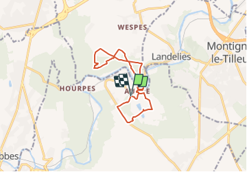

Length
11.3 km

Max alt
199 m

Uphill gradient
230 m
Km-Effort
14.4 km

Min alt
105 m

Downhill gradient
238 m
Boucle
Yes
Creation date :
2022-03-20 10:45:32.523
Updated on :
2022-03-23 06:56:52.763
3h15
Difficulty : Difficult

FREE GPS app for hiking
 SityTrail
IGN / Geographical institutes
SityTrail Plus
The world is yours!
About
Trail Nordic walking of 11.3 km to be discovered at Wallonia, Hainaut, Thuin. This trail is proposed by denissculier.
Description
Attention : un propriétaire "indélicat" ferme un sentier normalement praticable.
Positioning
Country:
Belgium
Region :
Wallonia
Department/Province :
Hainaut
Municipality :
Thuin
Location:
Unknown
Start:(Dec)
Start:(UTM)
594573 ; 5580079 (31U) N.
Comments