Trail Walking Coignières - Coignières boucle 20-3-22 - Photo

Coignières boucle 20-3-22

Nos randonnées en Ile de France

© OpenStreetMap contributors
Length
Length
24 km
Max alt
Max alt
183 m
Uphill gradient
Uphill gradient
397 m
Km-Effort
Km-Effort  
29 km
Min alt
Min alt
93 m
Downhill gradient
Downhill gradient
398 m
Boucle
Boucle
Yes
Creation date :
2022-03-20 08:11:46.289
Updated on :
2022-03-20 15:05:12.044

(0 Reviews)

Walking
Walking
6h51
Difficulty : Easy

Scan this QR Code to open this trail in the SityTrail application

FREE GPS app for hiking

Logo SityTrail SityTrail

IGN / Geographical institutes

Download SityTrail from the App Store Download SityTrail from Google Play

Logo SityTrail SityTrail World

The world is yours!

Download SityTrail from the App Store Download SityTrail from Google Play Download SityTrail on Huawei AppGallery

About

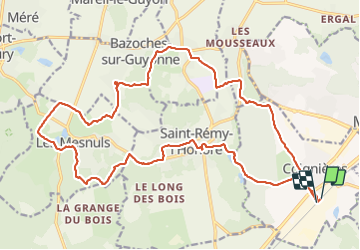
Trail Walking of 24 km to be discovered at Ile-de-France, Yvelines, Coignières. This trail is proposed by Randonneurs du XIème.

Description

des parties sur route

Elevation profile

Positioning

Country:
France
Region :
Ile-de-France
Department/Province :
Yvelines
Municipality :
Coignières
Location:
Unknown
Start:(UTM)
420785 ; 5399603 (31U) N.

Trails nearby

Trail Walking Dampierre-en-Yvelines - _La Genèse - Photo
Walking
GUIDE+

Walking

Easy
(12)
Dampierre-en-Yvelines, Ile-de-France, Yvelines, France
5.7 km | 7.1 km-effort
1h 30min
Yes
Trail Walking Dampierre-en-Yvelines - _Villages par mont et par vaux - Photo
Walking
GUIDE+

Walking

Easy
(9)
Dampierre-en-Yvelines, Ile-de-France, Yvelines, France
5.3 km | 7 km-effort
1h 26min
Yes
Trail Walking Auffargis - _Les 1000 facettes d''Auffargis - Photo
Walking
GUIDE+

Walking

Medium
(10)
Auffargis, Ile-de-France, Yvelines, France
10.2 km | 11.3 km-effort
2h 30min
Yes
Trail Walking Lévis-Saint-Nom - _Le Vallon du Pommeret - Photo
Walking
GUIDE+

Walking

Easy
(11)
Lévis-Saint-Nom, Ile-de-France, Yvelines, France
6.3 km | 8 km-effort
1h 30min
Yes
Trail Walking Bazoches-sur-Guyonne - _Les chaumières de Bazoches - Photo
Walking
GUIDE+

Walking

Medium
(2)
Bazoches-sur-Guyonne, Ile-de-France, Yvelines, France
8.5 km | 10.5 km-effort
2h 0min
Yes
Trail Walking Le Mesnil-Saint-Denis - _Entre ancienne châtellenie et Ville nouvelle - Photo
Walking
GUIDE+

Walking

Easy
(1)
Le Mesnil-Saint-Denis, Ile-de-France, Yvelines, France
8.6 km | 9.5 km-effort
2h 30min
Yes
Trail Walking Lévis-Saint-Nom - _L'Yvette - Photo
Walking
GUIDE+

Walking

Easy
(4)
Lévis-Saint-Nom, Ile-de-France, Yvelines, France
5.2 km | 7 km-effort
1h 29min
Yes
Trail Walking Le Tremblay-sur-Mauldre - rando du 12/03/2015 - Photo
Walking
microb

Walking

Easy
(1)
Le Tremblay-sur-Mauldre, Ile-de-France, Yvelines, France
7.1 km | 9.3 km-effort
1h 59min
Yes
Trail Walking Lévis-Saint-Nom - _Girouard - Photo
Walking
GUIDE+

Walking

Medium
(1)
Lévis-Saint-Nom, Ile-de-France, Yvelines, France
8 km | 10 km-effort
2h 0min
Yes


Close
My subscriptions